
படிமம்:Western sahara walls moroccan.png

இந்த முன்னோட்டத்தின் அளவு: 746 × 600 படப்புள்ளிகள் . மற்ற பிரிதிறன்கள்: 299 × 240 படப்புள்ளிகள் | 597 × 480 படப்புள்ளிகள் | 904 × 727 படப்புள்ளிகள் .
மூலக்கோப்பு (904 × 727 படவணுக்கள், கோப்பின் அளவு: 26 KB, MIME வகை: image/png)
| இது விக்கிமீடியா பொதுக்கோப்பகத்தில் இருக்கும் ஒரு கோப்பாகும். இக்கோப்பைக் குறித்து அங்கே காணப்படும் படிம விளக்கப் பக்கத்தை இங்கே கீழே காணலாம்.
|
சுருக்கம்
| விளக்கம் |
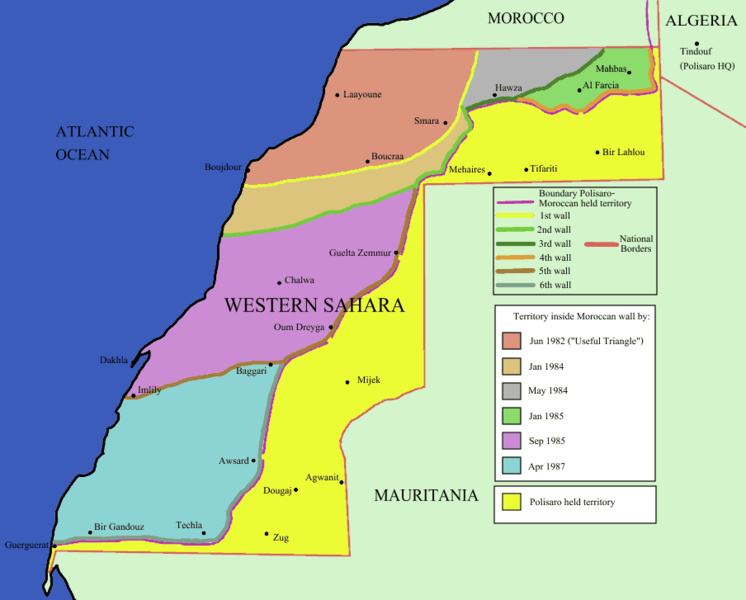
English: Map of the w:Moroccan Defensive Wall in w:Sahara - built over several stages during war against backed Algerian and Libya militias POLISARIO , shows the six Defensive walls built, & when the territory was behind Moroccan defensive wall. Also shows polisaro held territory who are based in Algeria (seen at top right). the map using UN old map map prior to ceasefire , polisario do not hold any territory within Moroccan borders , they are hosted in tindouf camps on Algerian territory [1] and this map [2]. |
|||
| மூலம் | Identical PNG copy of [3] | |||
| ஆசிரியர் | User:Roke | |||
| ஒத்தக்கோப்பு |
See: Category:Maps of the Moroccan Wall
[]
|


![[2]](https://web.archive.org/web/20110208043824/https://www.marrakech-expedition-4x4.com/images/map.jpg)
அனுமதி

|
GNU Free Documentation License விதிமுறைகளின் கீழ் இந்த ஆவணத்தை நகலெடுக்க, விநியோகிக்க மற்றும்/அல்லது மாற்றுவதற்கு அனுமதி வழங்கப்பட்டுள்ளது, Free Software Foundation;ஆல் வெளியிடப்பட்ட பதிப்பு 1.2 அல்லது அதற்குப் பிந்தைய பதிப்பு, மாற்றமில்லாத பிரிவுகள், முன் அட்டை உரைகள் மற்றும் பின் அட்டை உரைகள் இல்லாமல் வெளியிடப்பட்டது. GNU Free Documentation License என்ற தலைப்பில் உரிமத்தின் நகல் சேர்க்கப்பட்டுள்ளது. |
| இந்த கோப்பு Creative Commons Attribution-Share Alike 3.0 Unported உரிமத்தின் கீழ் உள்ளது. | ||
| ||
| This licensing tag was added to this file as part of the GFDL licensing update. |
கோப்பின் வரலாறு
குறித்த நேரத்தில் இருந்த படிமத்தைப் பார்க்க அந்நேரத்தின் மீது சொடுக்கவும்.
| நாள்/நேரம் | நகம் அளவு சிறுபடம் | அளவுகள் | பயனர் | கருத்து | |
|---|---|---|---|---|---|
| தற்போதைய | 13:44, 10 திசம்பர் 2009 | | 904 × 727 (26 KB) | Reisio | == {{int:filedesc}} == Map of the w:Moroccan Wall in w:Western Sahara - built over several stages, shows the six walls built, & when the territory was behind Moroccan wall. Also shows polisaro held territory who are based in Algeria (seen at top r |
கோப்பு பயன்பாடு
இப் படிமத்துக்கு இணைக்கப்பட்டுள்ள பக்கங்கள் எதுவும் இல்லை.
கோப்பின் முழுமையான பயன்பாடு
கீழ்கண்ட மற்ற விக்கிகள் இந்த கோப்பை பயன்படுத்துகின்றன:
- es.wikipedia.org-திட்டத்தில் இதன் பயன்பாடு