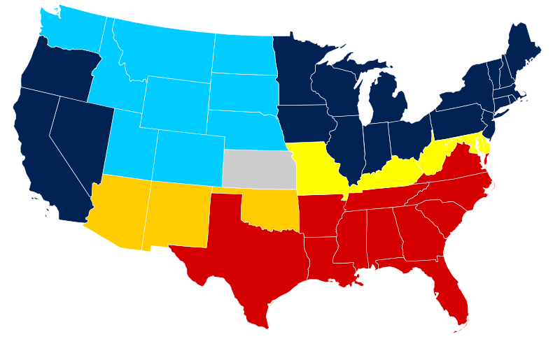
படிமம்:US Secession map 1865.svg
Appearance

Size of this PNG preview of this SVG file: 800 × 495 படப்புள்ளிகள். மற்ற பிரிதிறன்கள்: 320 × 198 படப்புள்ளிகள் | 640 × 396 படப்புள்ளிகள் | 1,024 × 633 படப்புள்ளிகள் | 1,280 × 791 படப்புள்ளிகள் | 2,560 × 1,583 படப்புள்ளிகள் | 959 × 593 படப்புள்ளிகள் .
மூலக்கோப்பு (SVG கோப்பு, பெயரளவில் 959 × 593 பிக்சல்கள், கோப்பு அளவு: 80 KB)
கோப்பின் வரலாறு
குறித்த நேரத்தில் இருந்த படிமத்தைப் பார்க்க அந்நேரத்தின் மீது சொடுக்கவும்.
| நாள்/நேரம் | நகம் அளவு சிறுபடம் | அளவுகள் | பயனர் | கருத்து | |
|---|---|---|---|---|---|
| தற்போதைய | 19:07, 16 பெப்பிரவரி 2011 |  | 959 × 593 (80 KB) | Holly Cheng | last version won't thumbnail; recreated from File:Blank US Map.svg |
| 09:50, 6 மார்ச்சு 2008 |  | 927 × 588 (233 KB) | Escondites | {{Information |Description= |Source= |Date= |Author= |Permission= |other_versions= }} | |
| 19:14, 26 சூன் 2007 |  | 882 × 553 (102 KB) | Nostrifikator | {{Tintazul |Description=United States map of 1865, show affiliation of states and territories regarding the Secession War (Civil War.) Legend: {{legend|#204A87|Union states}} {{legend|#729FCF|Union territories}} {{legend|#EDD400|Border Union states, permi | |
| 17:10, 23 பெப்பிரவரி 2007 |  | 882 × 553 (102 KB) | Tintazul | {{Tintazul |Description=United States map of 1865, show affiliation of states and territories regarding the Secession War (Civil War.) Legend: {{legend|#204A87|Union states}} {{legend|#729FCF|Union territories}} {{legend|#EDD400|Border Union states, permi |
கோப்பு பயன்பாடு
பின்வரும் பக்க இணைப்புகள் இப் படிமத்துக்கு இணைக்கபட்டுள்ளது(ளன):
கோப்பின் முழுமையான பயன்பாடு
கீழ்கண்ட மற்ற விக்கிகள் இந்த கோப்பை பயன்படுத்துகின்றன:
- af.wikipedia.org-திட்டத்தில் இதன் பயன்பாடு
- ar.wikipedia.org-திட்டத்தில் இதன் பயன்பாடு
- da.wikipedia.org-திட்டத்தில் இதன் பயன்பாடு
- el.wikipedia.org-திட்டத்தில் இதன் பயன்பாடு
- en.wikipedia.org-திட்டத்தில் இதன் பயன்பாடு
- Talk:Abraham Lincoln
- Talk:David Rice Atchison
- Talk:Frigate
- Talk:Jefferson Davis
- Talk:Mark Twain
- Talk:Submarine
- Talk:United States Navy
- Talk:United States Marine Corps
- Talk:William Tecumseh Sherman
- Talk:Harpers Ferry, West Virginia
- Talk:Reconstruction era
- Talk:The Birth of a Nation
- Talk:USS Monitor
- Talk:Emancipation Proclamation
- Talk:Kit Carson
- Talk:HMS Scorpion (1863)
- Talk:Confederate States of America
- Talk:Arlington National Cemetery
- Talk:Second Battle of Bull Run
- Talk:Williamsburg, Virginia
- Talk:Slavery and States' Rights
- Talk:George Pickett
- Talk:Abner Doubleday
- Talk:Battle of the Crater
- Talk:Battle of Antietam
- Talk:Sidney Lanier
- Talk:Henry Morton Stanley
- Talk:Winfield Scott Hancock
- Talk:Buffalo Bill
- Talk:Albert Sidney Johnston
- Talk:Harriet Tubman
- Talk:Lucius Quintus Cincinnatus Lamar
- Talk:George Dewey
- Talk:P. B. S. Pinchback
- Talk:Battle of New Market
- Talk:Fort Donelson
- Talk:Taps (bugle call)
- Talk:Joseph Wheeler
- Talk:George Armstrong Custer
- Talk:First Battle of Bull Run
- Talk:Oliver Otis Howard
- Talk:John Stith Pemberton
- Talk:USS United States (1797)
- Talk:Alfred Packer
சிறப்பு பக்கம்-மொத்த பயன்பாடு - இதன் மூலம் இந்த கோப்பின் மொத்த பயன்பாட்டை அறிய முடியும்

