உள்ளடக்கத்துக்குச் செல்

படிமம்:Map of Sunda and Sahul.svg

மற்ற மொழிகளில் ஆதரிக்கப்படாத பக்க உள்ளடக்கம்.
கட்டற்ற கலைக்களஞ்சியமான விக்கிப்பீடியாவில் இருந்து.

மூலக்கோப்பு (SVG கோப்பு, பெயரளவில் 976 × 907 பிக்சல்கள், கோப்பு அளவு: 847 KB)

. இல் இப்படத்தை தோன்றச் செய்
இது விக்கிமீடியா பொதுக்கோப்பகத்தில் இருக்கும் ஒரு கோப்பாகும். இக்கோப்பைக் குறித்து அங்கே காணப்படும் படிம விளக்கப் பக்கத்தை இங்கே கீழே காணலாம்.
பொதுக்கோப்பகம் ஒரு கட்டற்ற கோப்புகளின் சேமிப்பகமாகும். நீங்களும் உதவலாம்.

சுருக்கம்

Description
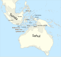
Català: Mapa de Sonda i Sahul (marcat per un contorn de 125 m de profunditat) i la Línia de Wallace, la Línia de Weber i la Línia de Lydekker.
English: Map of Sunda and Sahul (marked by 125m depth contour) and the Wallace Line, the Weber Line and the Lydekker Line.
Македонски: Карта на Сунда и Сахул (изобата 125 м) со Волесовата, Веберовата и Лидекеровата Линија.
Key
InfoField
 
sea
 
current land extent (0BP)
 
land extent at Last Glacial Maximum (23000+-3000 BP)
நாள்
மூலம்

சொந்த முயற்சி, based on file:map of Sunda and Sahul.png and using

படைப்பாளி
 Geotemporal data
Spatial reference system equirectangular
Bounding box
N: 20.2°N
W: 91°E E: 162.8°E
S: 45°S
ஒத்தக்கோப்பு
Other related versions: Map of Sunda and Sahul.png


Translate this file This SVG file contains embedded text that can be translated into your language, using any capable SVG editor, text editor or the SVG Translate tool. For more information see: About translating SVG files.
This file is translated using SVG <switch> elements. All translations are stored in the same file! Learn more.

For most Wikipedia projects, you can embed the file normally (without a lang parameter). The Wikipedia will use its language if the SVG file supports that language. For example, the German Wikipedia will use German if the SVG file has German. To embed this file in a particular language use the lang parameter with the appropriate language code, e.g. [[File:Map of Sunda and Sahul.svg|lang=en]] for the English version. Do not specify a lang parameter if it is not needed. The parameter may prevent the use of a subsequent translation.

To translate the text into your language, you can use the SVG Translate tool. Alternatively, you can download the file to your computer, add your translations using whatever software you're familiar with, and re-upload it with the same name. You will find help in Graphics Lab if you're not sure how to do this.

அனுமதி

இந்த ஆக்கத்தின் காப்புரிமையாளரான நான் இதனைப் பின்வரும் உரிமத்தின் கீழ் வெளியிடுகின்றேன்:
w:ta:கிரியேட்டிவ் காமன்ஸ்
பண்புக்கூறுகள் அதே மாதிரி பகிர்
This file is licensed under the Creative Commons Attribution-Share Alike 4.0 International license.
நீங்கள் சுதந்திரமாக:
  • பகிர்ந்து கொள்ள – வேலையை நகலெடுக்க, விநியோகிக்க மற்றும் அனுப்ப
  • மீண்டும் கலக்க – வேலைக்கு பழகிக்கொள்ள.
கீழ்க்காணும் விதிகளுக்கு ஏற்ப,
  • பண்புக்கூறுகள் – நீங்கள் பொருத்தமான உரிமையை வழங்க வேண்டும், உரிமத்திற்கான இணைப்பை வழங்க வேண்டும் மற்றும் மாற்றங்கள் செய்யப்பட்டிருந்தால் குறிப்பிட வேண்டும். நீங்கள் ஏற்புடைய எந்த முறையிலும் அவ்வாறு செய்யலாம், ஆனால் எந்த வகையிலும் உரிமதாரர் உங்களை அல்லது உங்கள் பயன்பாட்டிற்கு ஒப்புதல் அளிக்கும் படி பரிந்துரைக்க கூடாது.
  • அதே மாதிரி பகிர் – நீங்கள் ரீமிக்ஸ் செய்தாலோ, உருமாற்றம் செய்தாலோ அல்லது பொருளை உருவாக்கினாலோ, உங்கள் பங்களிப்புகளை அல்லது இணக்கமான உரிமம் கீழ் அசலாக விநியோகிக்க வேண்டும்.
GNU head GNU Free Documentation License விதிமுறைகளின் கீழ் இந்த ஆவணத்தை நகலெடுக்க, விநியோகிக்க மற்றும்/அல்லது மாற்றுவதற்கு அனுமதி வழங்கப்பட்டுள்ளது, Free Software Foundation;ஆல் வெளியிடப்பட்ட பதிப்பு 1.2 அல்லது அதற்குப் பிந்தைய பதிப்பு, மாற்றமில்லாத பிரிவுகள், முன் அட்டை உரைகள் மற்றும் பின் அட்டை உரைகள் இல்லாமல் வெளியிடப்பட்டது. GNU Free Documentation License என்ற தலைப்பில் உரிமத்தின் நகல் சேர்க்கப்பட்டுள்ளது.
நீர் உமக்கு விருப்பமான உரிமத்தை தேர்ந்தெடுக்கலாம்.

Captions

Add a one-line explanation of what this file represents

copyright status ஆங்கிலம்

copyrighted ஆங்கிலம்

source of file ஆங்கிலம்

original creation by uploader ஆங்கிலம்

கோப்பின் வரலாறு

குறித்த நேரத்தில் இருந்த படிமத்தைப் பார்க்க அந்நேரத்தின் மீது சொடுக்கவும்.

நாள்/நேரம்நகம் அளவு சிறுபடம்அளவுகள்பயனர்கருத்து
தற்போதைய08:33, 20 ஆகத்து 202408:33, 20 ஆகத்து 2024 இலிருந்த பதிப்புக்கான சிறு தோற்றம்976 × 907 (847 KB)Bjankuloski06File uploaded using svgtranslate tool (https://svgtranslate.toolforge.org/). Added translation for mk.
23:42, 12 ஏப்பிரல் 202423:42, 12 ஏப்பிரல் 2024 இலிருந்த பதிப்புக்கான சிறு தோற்றம்976 × 907 (845 KB)ManlleusFile uploaded using svgtranslate tool (https://svgtranslate.toolforge.org/). Added translation for ca.
23:34, 12 ஏப்பிரல் 202423:34, 12 ஏப்பிரல் 2024 இலிருந்த பதிப்புக்கான சிறு தோற்றம்976 × 907 (845 KB)ManlleusFile uploaded using svgtranslate tool (https://svgtranslate.toolforge.org/). Added translation for ca.
15:07, 16 சனவரி 202315:07, 16 சனவரி 2023 இலிருந்த பதிப்புக்கான சிறு தோற்றம்976 × 907 (841 KB)Kanguole{{Map |Description={{en|Map of Sunda and Sahul (marked by 125m depth contour) and the Wallace Line, the Weber Line and the Lydekker Line.}} |Projection=equirectangular |Latitude=-45/20.2 |Longitude=91/162.8 |Warp status=skip |Source={{own}}, using * Coastline from [http://www.naturalearthdata.com/downloads/50m-physical-vectors/ Natural Earth 1:50m Physical Vectors] * 125m depth contour derived...

பின்வரும் பக்க இணைப்புகள் இப் படிமத்துக்கு இணைக்கபட்டுள்ளது(ளன):

கோப்பின் முழுமையான பயன்பாடு

கீழ்கண்ட மற்ற விக்கிகள் இந்த கோப்பை பயன்படுத்துகின்றன:

மேனிலைத் தரவு

"https://ta.wikipedia.org/wiki/படிமம்:Map_of_Sunda_and_Sahul.svg" இலிருந்து மீள்விக்கப்பட்டது