
படிமம்:La2-demis-caribbean.png

இந்த முன்னோட்டத்தின் அளவு: 800 × 504 படப்புள்ளிகள் . மற்ற பிரிதிறன்கள்: 320 × 201 படப்புள்ளிகள் | 640 × 403 படப்புள்ளிகள் | 891 × 561 படப்புள்ளிகள் .
மூலக்கோப்பு (891 × 561 படவணுக்கள், கோப்பின் அளவு: 149 KB, MIME வகை: image/png)
| இது விக்கிமீடியா பொதுக்கோப்பகத்தில் இருக்கும் ஒரு கோப்பாகும். இக்கோப்பைக் குறித்து அங்கே காணப்படும் படிம விளக்கப் பக்கத்தை இங்கே கீழே காணலாம்.
|
சுருக்கம்
| விளக்கம் |
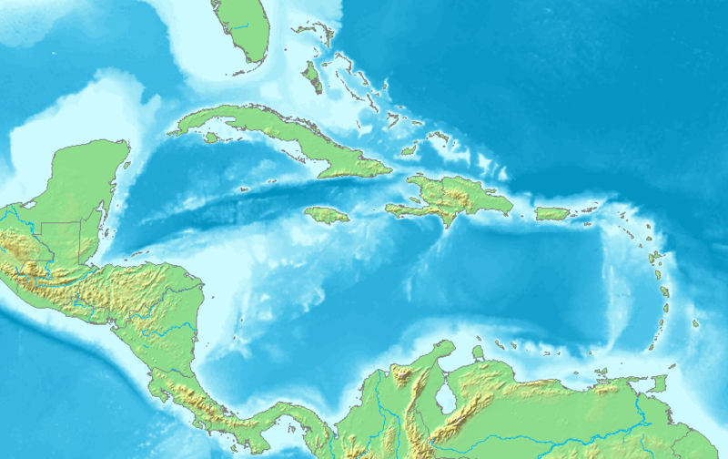
English: Map of the Caribbean and Central America.
Bounding box West -93°, South 7°, East -58°, North 28°. Center at 17°30′00″N 75°30′00″W / 17.50000°N 75.50000°W. |
| நாள் | |
| மூலம் | Demis map server |
| ஆசிரியர் | Demis map server |
| ஒத்தக்கோப்பு | Derivative works of this file: La2-demis-caribbean gs.png |
This image is in the public domain because it came from the site https://www.demis.nl/products/web-map-server/examples/ and was released by the copyright holder. Permission is granted to copy, distribute and/or modify this map since it is based on free of copyright images from: www.demis.nl. See also approval email on de.wp and its clarification.
|
| This work has been released into the public domain by its copyright holder, www.demis.nl. This applies worldwide. சில நாடுகளில் இது சாத்தியமில்லாது போகலாம். அவ்வாறாயின் : www.demis.nl grants anyone the right to use this work for any purpose, without any conditions, unless such conditions are required by law.
|
கோப்பின் வரலாறு
குறித்த நேரத்தில் இருந்த படிமத்தைப் பார்க்க அந்நேரத்தின் மீது சொடுக்கவும்.
| நாள்/நேரம் | நகம் அளவு சிறுபடம் | அளவுகள் | பயனர் | கருத்து | |
|---|---|---|---|---|---|
| தற்போதைய | 05:10, 23 நவம்பர் 2018 | | 891 × 561 (149 KB) | Opencooper | rm watermark |
| 13:20, 2 செப்டெம்பர் 2005 |  | 891 × 561 (170 KB) | LA2 | Map of the Carribean and Central America. Bounding box West -93°, South 7°, East -58°, North 28°. {{demis-pd}} category:maps of America |
கோப்பு பயன்பாடு
பின்வரும் 2 பக்கங்கள் இணைப்பு இப் படிமத்துக்கு இணைக்கபட்டுள்ளது(ளன):
கோப்பின் முழுமையான பயன்பாடு
கீழ்கண்ட மற்ற விக்கிகள் இந்த கோப்பை பயன்படுத்துகின்றன:
- am.wikipedia.org-திட்டத்தில் இதன் பயன்பாடு
- ar.wikipedia.org-திட்டத்தில் இதன் பயன்பாடு
- كريستوفر كولومبوس
- تصنيف:أمريكا الشمالية
- كوبا
- بليز
- أمريكا الشمالية
- سورينام
- غيانا
- جامايكا
- غرينادا
- تصنيف:جامايكا
- مونتسرات
- سانت فينسنت والغرينادين
- ترينيداد وتوباغو
- أروبا
- مارتينيك
- تصنيف:ترينيداد وتوباغو
- دولار بربادوسي
- باربادوس
- دولار بهامي
- ناساو
- نشيد جزر البهاما الوطني
- اللغة الهولندية
- .an
- .aw
- البحر الكاريبي
- الكاريبي
- جزر الأنتيل
- جزر الأنتيل الكبرى
- جزر الأنتيل الصغرى
- هسبنيولا
- بورتوريكو
- ترينيداد
- أنتيغوا وباربودا
- .vi
- جزر الأنتيل الهولندية
- جزر العذراء
- جمهورية الدومينيكان
- هايتي
- غوادلوب
- جزر العذراء البريطانية
- جزر العذراء الأمريكية
- دومينيكا
- تصنيف:جمهورية الدومينيكان
- تصنيف:الكاريبي
- سانت لوسيا
- علم أروبا
- سانت كيتس ونيفيس
- بيزو كوبي
- إيان فلمنغ
சிறப்பு பக்கம்-மொத்த பயன்பாடு - இதன் மூலம் இந்த கோப்பின் மொத்த பயன்பாட்டை அறிய முடியும்