உள்ளடக்கத்துக்குச் செல்

படிமம்:Ebola 2014 outbreak map of Guinea, Liberia, and Sierra Leone.png

மற்ற மொழிகளில் ஆதரிக்கப்படாத பக்க உள்ளடக்கம்.
கட்டற்ற கலைக்களஞ்சியமான விக்கிப்பீடியாவில் இருந்து.

மூலக்கோப்பு (975 × 756 படவணுக்கள், கோப்பின் அளவு: 1,016 KB, MIME வகை: image/png)

இது விக்கிமீடியா பொதுக்கோப்பகத்தில் இருக்கும் ஒரு கோப்பாகும். இக்கோப்பைக் குறித்து அங்கே காணப்படும் படிம விளக்கப் பக்கத்தை இங்கே கீழே காணலாம்.
பொதுக்கோப்பகம் ஒரு கட்டற்ற கோப்புகளின் சேமிப்பகமாகும். நீங்களும் உதவலாம்.

சுருக்கம்

விளக்கம்
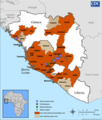
English: This is a map from a government publication on the spread of ebola in Guinea Sierra Leone as of July 2014 (Original file).
• 1. Update: 2014-06-26;
• 2. Update: 2014-08-09;
• 3. Update: 2014-09-04;
日本語: ギニアとシエラレオネでのエボラの流行状況 2014年6月時点
நாள்
மூலம் https://www.cdc.gov/vhf/ebola/resources/distribution-map-guinea-outbreak.html
ஆசிரியர் CDC
ஒத்தக்கோப்பு Animation (GIF)
This health map image could be re-created using vector graphics as an SVG file. This has several advantages; see Commons:Media for cleanup for more information. If an SVG form of this image is available, please upload it and afterwards replace this template with {{vector version available|new image name}}.


It is recommended to name the SVG file “Ebola 2014 outbreak map of Guinea, Liberia, and Sierra Leone.svg”—then the template Vector version available (or Vva) does not need the new image name parameter.

அனுமதி

Public domain
This image is a work of the Centers for Disease Control and Prevention, part of the United States Department of Health and Human Services, taken or made as part of an employee's official duties. As a work of the U.S. federal government, the image is in the public domain.

Original upload log

  • 2014-07-06 13:44 HAdG 956×1126× (643811 bytes) Removed borders and watermarks as per tags; changed to PNG format (hence new file).

Previous version as JPEG

The original description page was here. All following user names refer to en.wikipedia.
  • 2014-06-18 22:46 Donners 960×1132× (287070 bytes) Updated to 18 June 2014
  • 2014-05-24 12:59 X1987x 800×941× (125421 bytes) May 23 update. Includes cases in Dabola, Guinea
  • 2014-04-15 00:09 Justanonymous 800×942× (131445 bytes) Uploading a public-domain item using [[Wikipedia:File_Upload_Wizard|File Upload Wizard]]

Captions

Add a one-line explanation of what this file represents

6 சூலை 2014

கோப்பின் வரலாறு

குறித்த நேரத்தில் இருந்த படிமத்தைப் பார்க்க அந்நேரத்தின் மீது சொடுக்கவும்.

நாள்/நேரம்நகம் அளவு சிறுபடம்அளவுகள்பயனர்கருத்து
தற்போதைய07:48, 30 செப்டெம்பர் 201407:48, 30 செப்டெம்பர் 2014 இலிருந்த பதிப்புக்கான சிறு தோற்றம்975 × 756 (1,016 KB)Ypna26 September
14:07, 27 செப்டெம்பர் 201414:07, 27 செப்டெம்பர் 2014 இலிருந்த பதிப்புக்கான சிறு தோற்றம்975 × 762 (1.04 MB)Twotwo2019update 24, september
03:51, 19 செப்டெம்பர் 201403:51, 19 செப்டெம்பர் 2014 இலிருந்த பதிப்புக்கான சிறு தோற்றம்1,000 × 1,172 (1.32 MB)Twotwo2019update September 14.
12:37, 10 செப்டெம்பர் 201412:37, 10 செப்டெம்பர் 2014 இலிருந்த பதிப்புக்கான சிறு தோற்றம்1,200 × 1,415 (1.25 MB)Twotwo2019September 4. update.
12:38, 15 ஆகத்து 201412:38, 15 ஆகத்து 2014 இலிருந்த பதிப்புக்கான சிறு தோற்றம்1,200 × 1,414 (1.17 MB)Twotwo2019update August 14, 2014
11:15, 9 ஆகத்து 201411:15, 9 ஆகத்து 2014 இலிருந்த பதிப்புக்கான சிறு தோற்றம்960 × 1,128 (828 KB)Twotwo2019update version as 8 August, 2014
12:44, 26 சூலை 201412:44, 26 சூலை 2014 இலிருந்த பதிப்புக்கான சிறு தோற்றம்960 × 1,128 (741 KB)Ypnaupdated version as of 24 July, 2014
12:42, 6 சூலை 201412:42, 6 சூலை 2014 இலிருந்த பதிப்புக்கான சிறு தோற்றம்956 × 1,126 (629 KB)HAdGUser created page with UploadWizard

இப் படிமத்துக்கு இணைக்கப்பட்டுள்ள பக்கங்கள் எதுவும் இல்லை.

கோப்பின் முழுமையான பயன்பாடு

கீழ்கண்ட மற்ற விக்கிகள் இந்த கோப்பை பயன்படுத்துகின்றன:

மேனிலைத் தரவு

"https://ta.wikipedia.org/wiki/படிமம்:Ebola_2014_outbreak_map_of_Guinea,_Liberia,_and_Sierra_Leone.png" இலிருந்து மீள்விக்கப்பட்டது