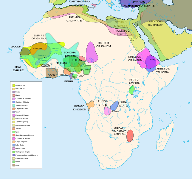
படிமம்:African-civilizations-map-pre-colonial.svg
Appearance

Size of this PNG preview of this SVG file: 644 × 600 படப்புள்ளிகள். மற்ற பிரிதிறன்கள்: 258 × 240 படப்புள்ளிகள் | 515 × 480 படப்புள்ளிகள் | 824 × 768 படப்புள்ளிகள் | 1,099 × 1,024 படப்புள்ளிகள் | 2,198 × 2,048 படப்புள்ளிகள் | 1,390 × 1,295 படப்புள்ளிகள் .
மூலக்கோப்பு (SVG கோப்பு, பெயரளவில் 1,390 × 1,295 பிக்சல்கள், கோப்பு அளவு: 488 KB)
கோப்பின் வரலாறு
குறித்த நேரத்தில் இருந்த படிமத்தைப் பார்க்க அந்நேரத்தின் மீது சொடுக்கவும்.
| நாள்/நேரம் | நகம் அளவு சிறுபடம் | அளவுகள் | பயனர் | கருத்து | |
|---|---|---|---|---|---|
| தற்போதைய | 06:49, 16 பெப்பிரவரி 2024 |  | 1,390 × 1,295 (488 KB) | Ahiise2 | Changed "Bachwezi Empire" to "Kitara Empire" to be consistent with other versions of the file |
| 04:11, 20 செப்டெம்பர் 2011 |  | 1,390 × 1,295 (487 KB) | Alphathon | moved rivers to the top | |
| 03:33, 20 செப்டெம்பர் 2011 |  | 1,390 × 1,295 (487 KB) | Alphathon | One more time… | |
| 03:27, 20 செப்டெம்பர் 2011 |  | 1,390 × 1,295 (486 KB) | Alphathon | Found some more errors | |
| 03:16, 20 செப்டெம்பர் 2011 |  | 1,390 × 1,295 (489 KB) | Alphathon | Some final clean-ups and fixes | |
| 02:59, 20 செப்டெம்பர் 2011 |  | 1,390 × 1,295 (471 KB) | Alphathon | Apparently I duped The Persian Archaemenid Empire (now fixed). Also fixed borders of said empire. | |
| 02:50, 20 செப்டெம்பர் 2011 |  | 1,390 × 1,295 (452 KB) | Alphathon | Reinstated "Akan" on proper vector version of the map and tidied up some sea-borders (some still need looking at) | |
| 02:02, 20 செப்டெம்பர் 2011 |  | 1,390 × 1,295 (297 KB) | Alphathon | Reverted to version as of 22:11, 20 July 2010 - previous version was not a vector image | |
| 17:42, 26 மார்ச்சு 2011 |  | 2,000 × 1,863 (2.66 MB) | Medicineman84 | == {{int:filedesc}} == {{Information |Description=Africa History Atlas Diachronic map showing pre-colonial cultures of Africa (spanning roughly 500 BCE to 1500 CE) This map is "an artistic interpretation" using multiple and disparate sources. |Source={ | |
| 22:11, 20 சூலை 2010 |  | 1,390 × 1,295 (297 KB) | Ras67 | font fault resolved |
கோப்பு பயன்பாடு
பின்வரும் பக்க இணைப்புகள் இப் படிமத்துக்கு இணைக்கபட்டுள்ளது(ளன):
கோப்பின் முழுமையான பயன்பாடு
கீழ்கண்ட மற்ற விக்கிகள் இந்த கோப்பை பயன்படுத்துகின்றன:
- af.wikipedia.org-திட்டத்தில் இதன் பயன்பாடு
- anp.wikipedia.org-திட்டத்தில் இதன் பயன்பாடு
- ar.wikipedia.org-திட்டத்தில் இதன் பயன்பாடு
- ast.wikipedia.org-திட்டத்தில் இதன் பயன்பாடு
- azb.wikipedia.org-திட்டத்தில் இதன் பயன்பாடு
- be.wikipedia.org-திட்டத்தில் இதன் பயன்பாடு
- bn.wikipedia.org-திட்டத்தில் இதன் பயன்பாடு
- ca.wikipedia.org-திட்டத்தில் இதன் பயன்பாடு
- da.wikipedia.org-திட்டத்தில் இதன் பயன்பாடு
- de.wikipedia.org-திட்டத்தில் இதன் பயன்பாடு
- en.wikipedia.org-திட்டத்தில் இதன் பயன்பாடு
- Scramble for Africa
- Pre-colonial history of the Democratic Republic of the Congo
- Akan people
- Empire of Kitara
- User:Peter Isotalo/slask
- User:Ackees/WikiProject African history
- User:DyinRich/Something Else
- Portal:Pan-Africanism/Selected history
- Portal:Pan-Africanism/Selected history/1
- List of wars of succession
- User:Falcaorib/Africa
- en.wikibooks.org-திட்டத்தில் இதன் பயன்பாடு
- eu.wikipedia.org-திட்டத்தில் இதன் பயன்பாடு
- fi.wikipedia.org-திட்டத்தில் இதன் பயன்பாடு
- fi.wikibooks.org-திட்டத்தில் இதன் பயன்பாடு
- fr.wikipedia.org-திட்டத்தில் இதன் பயன்பாடு
சிறப்பு பக்கம்-மொத்த பயன்பாடு - இதன் மூலம் இந்த கோப்பின் மொத்த பயன்பாட்டை அறிய முடியும்


